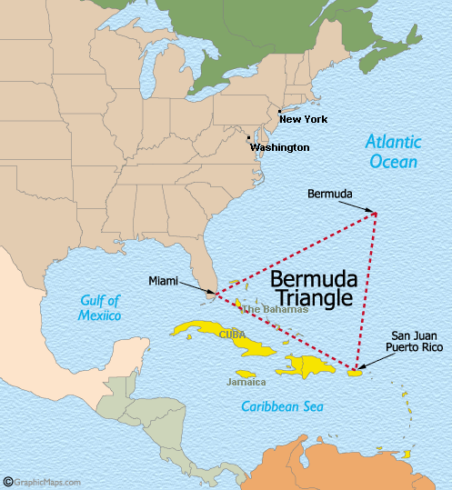
The "Bermuda or Devil's Triangle" is an imaginary area of the Atlantic noted for a high incidence of unexplained losses of ships,
boats, and aircraft. The apexes of the triangle are generally accepted to be Bermuda, Miami, Florida, and San Juan, Puerto Rico.
In the past, extensive but futile Coast Guard searches prompted by disappearances such as the sinking of USS Cyclops in 1918,
the loss of "Flight 19" in 1945 and that of the tanker SS Marine Sulphur Queen in 1963 that have lent credence to a popular
belief in the mystery and supposed supernatural qualities of the area.
A 1952 article in "Fate" magazine, entitled "Sea Mystery at our Back Door" by George X Sand, laid out for the first time the now
familiar triangular region in the Atlantic. Sand was the first to suggest a supernatural element to the loss of "Flight 19" in 1945
but it was Vincent Gaddis' article in 1964 entitled "The Deadly Bermuda Triangle", which argued that these disappearances were
part of a pattern of strange events in the region. In his book "Invisible Horizons: True Mysteries of the Sea" in 1965,
he included an account the "Loss of Flight 19" which probably led to it becoming the most notorious incident associated with
the mystery of the "Bermuda Triangle".
The US Coast Guard, and most other official sources are unimpressed with supernatural explanations of disasters at sea. The area is one
of the most heavily-trafficked for aircraft and shipping in the World and it has been their experience that the combined forces of nature
and the unpredictability of mankind can outwit even the most elaborate and far-fetched science fiction explanations.
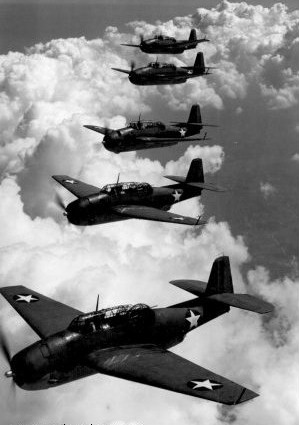
The Loss of Flight 19
On 5th December 1945, Five TBM Avengers take-off on a 2-hour routine training mission from Fort Lauderdale, Florida. The weather is excellent.
90 minutes later, the Tower receives a call from the flight leader, sounding confused,
"Cannot see land. We seem to be off course." he says. When asked, "What is your position?", he replies "We cannot be sure where we are. Repeat: Cannot see land."
When contact is resumed, the voices of the crews are heard, sounding disoriented, "We can't find west. Everything is wrong. We can't be sure of any direction.
Everything looks strange, even the ocean." There are further incoherent ramblings until, "It looks like we are entering white water ... We're completely lost."
Within minutes, a Mariner flying boat, with 13 crew and rescue equipment, is on its way to their last estimated position. 10 minutes later, it checks-in
and is never heard from again. All disappear without trace.
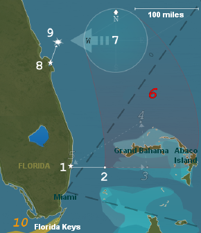
An Explanation (reference to map left)
From Fort Lauderdale (1), the mission was to fly east 56 miles to Hen & Chicken Shoals (2) for bombing practice, then another 67 miles,
before turning north (3), flying over Grand Bahama Island 73 miles to (4), then returning south-west to base. The mission
was a navigation test by "dead reckoning" but the aircraft clocks were missing and it is not certain that all the pilots had watches.
The weather forecast was for scattered showers with visibility of 6-8 miles, 20-30 knot winds and seas moderate to rough.
The flight instructor, Taylor, arrived late and requested not to lead the mission but his request was denied. Initially blamed,
he had a reputation of "flying by the seat of his pants" and had already got lost and had to ditch his plane twice before. It has also been speculated
that he was suffering psychological problems.
Carrying-out their bombing run (2), they proceeded to the first turn (3) but it is possible they overshot and were already further east by this time, as
Taylor reported land on his right (probably Abaco Island). For no known reason, he became convinced his compasses were faulty and that they were over
the Florida Keys (10), so he turned north-east, thinking he would soon strike Florida but in fact, he was heading out into the Atlantic (6).
From their radio transmissions, it is known that some of the pilots disagreed with Taylor but military discipline made them follow him. Nevertheless,
when their course failed to strike land, it is known that they turned west but in deteriorating weather, they were now running out of fuel. Triangulation
of their fading radio signals finally places them within 100 miles of (7) heading west.
The TBM Avenger was not known for its ditching abilities, and in now rough seas and after dark, it is unsurprising that no wreackage was found. As for the
Mariner Flying Boat, which took-off from (8), a number of eye-witnesses at sea reported an explosion at about (9). A mechanical fault is the most likely, albeit coincidental,
cause of the Flying Boat's crash.
Following an appeal by Taylor's mother, the Official Navy Investigation Report was subsequently amended to "cause unknown" and praised Taylor for doing his best.
All this probably added to the speculation as to what was the true cause of the loss of Flight 19.
Countless theories have been offered to explain the many disappearances throughout the history of this area,
the most practical being either environmental or those citing human error. Magnetic compass variation is frequently mentioned but this phenomenon is well-known
to navigators and can be compensated for. It is true that an area called the "Devil's Sea" by Japanese and Filipino seamen, located off the east coast of Japan,
exhibits an unusual magnetic variation pattern and it is also known for its mysterious disappearances. Such an association with the "Bermuda or Devil's Triangle"
is however unwarranted but perhaps a subconscious one.
Another environmental factor is the character of the Gulf Stream. It is extremely swift and turbulent and can quickly erase any evidence
of a disaster. The unpredictable Caribbean-Atlantic weather pattern also plays its role. Sudden local thunderstorms and waterspouts
can often spell disaster for pilots and mariners alike.
Additonally, the topography of the ocean floor varies from extensive shoals around the islands to some of the deepest marine trenches in the
World. With the interaction of strong currents over the many reefs, the topography is in a constant state of flux and the development of
new navigational hazards is often swift.
Finally, not to be underestimated is human error. A large number of pleasure boats travel the waters between Florida and the Bahamas. All
too often, crossings are attempted with too small a boat, insufficient knowledge of the area's hazards, or simply a lack of good seamanship.
As for time-tunnels and aliens, that's another story......